Archived Content
Information identified as archived is provided for reference, research or recordkeeping purposes. It is not subject to the Government of Canada Web Standards and has not been altered or updated since it was archived. Please contact us to request a format other than those available.
Chapter D9-2 ver. 1
MINERAL CLAIM SURVEYS IN YUKON - PLACER
Table of Contents
- Survey Instructions Home
-
Part B - Agreements
-
B2 - Intergovernmental Agreements
-
Part D - Survey Standards
- D1 - Official Surveys
- D2 - Explanatory Plans
- D3 - Strata Surveys
- D4 - Condominium Surveys
- D5 - Registration and Land Use Area Plans
- D6 - Oil and Gas Surveys in Indian Reserves
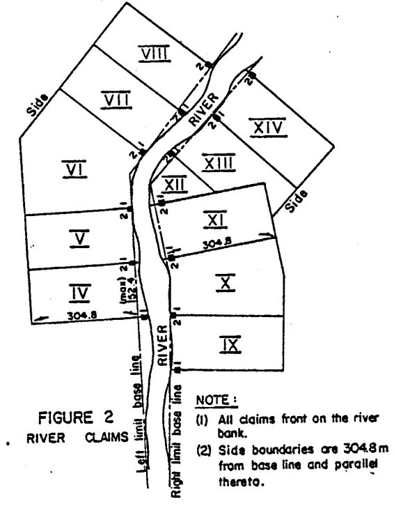
- D7 - Oil and Gas Surveys in the Territories and Offshore
- D8 - Mineral Claim Surveys in the Northwest Territories and Nunavut
- D9 - Mineral Claim Surveys in Yukon
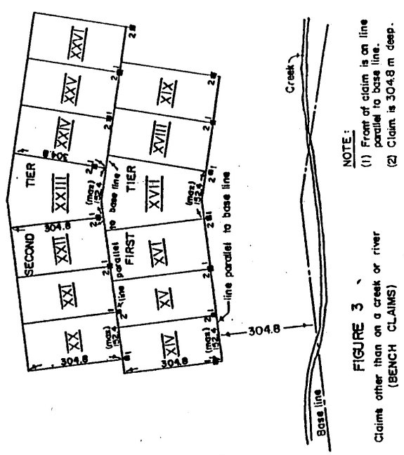
- D10 - Field Monitoring of Exterior Boundaries and Interior Frameworks
- D11 - Boundary Maintenance
- D12 - Control Surveys
- D13 - Basemapping
- D14 - Land Descriptions
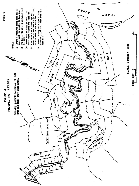
- D15 - Survey Reports
- D16 - As-built Surveys
- D17 - Guidelines for the preparation of Legal Description Reports for the Individual First Nation Agreement under the First Nations Land Management Act
-
Part E - Appendices
Note:
The general instructions in Part B of the Manual of Instructions for the Survey of Canada Lands (2nd Edition) will apply to the subject surveys insofar as they can be made to apply, and portions of Part D apply as indicated.
Chapter Sections
Base Lines
1. Placer claims are usually located along a creek or river, the staker claiming a portion of the valley measured along the general direction thereof. To render such holdings systematic and prevent conflict they are required under the Act to conform to a base line established by official survey.
2. A base line is located along the general direction of the central bottom lands of the valley but not necessarily in the centre thereof. For a creek it should be near enough to the stream to ensure that all creek locations include the full width of the creek. For a river one base line should be located near each bank. After the survey of a base line has been advertised and approved by the Commissioner, it is final. The base line must therefore be located with care, and must be monumented and referenced in such a manner that its destruction becomes unlikely and any necessary re-establishment straightforward. Wherever possible it should be connected to geodetic control.
3. Before the survey of a new base line the Surveyor General will issue specific instructions. The Northern Affairs Program, Yukon Region Mineral Resources Administration and the Regional Surveyor will work together in selecting and plotting the approximate location on a topographic map or photomap. It is important that large deflections be avoided as much as possible so that claims will not depart too much from rectangular.
4. Resurvey an old base line from best evidence of its original position. This may in some cases be the topographic features tied to and shown in the original survey.
5. Monument a base line at each point of deflection and at intervals not exceeding 1 km, preferably intervisible, using C.L.S. pattern posts with ancillary monumentation (sec. B6: 22 & 29, 2nd Edition of the Manual). Mark posts with the letters BL and identifying numbers.
6. In addition to monumenting the base line itself, place reference monuments in locations where they are least likely to be destroyed. For this purpose long iron bars 2.5 cm in diameter (or square) or C.L.S. pattern posts would be suitable. To reduce the probability of these being mistaken for base line monuments by stakers they should be clearly identified with letters REF (as well as a number), and should not be made overly conspicuous.
Claims
7. The provisions of Chapter D1 except sec. D1: 4; sections D3: 2, 4 and 10; Chapter D4; and Chapter D5 of the Manual (2nd Edition) also apply to surveys of placer claims in the Yukon.
8. For the purpose of sec. 39 of the Act, surveys of claims will not be definitive without specific instructions.
9. Three kinds of claims are dealt with under the Act - those situated on a creek (creek claims), those fronting on a river (river claims) and those situated elsewhere, which we will refer to for convenience as "bench claims". The length of the location line measured on the base line for creek or river claims or measured on the front line parallel to the base line for "bench claims" may not exceed 152.4 m (500 feet) except in the case of discovery claims. In all cases the claim boundaries shall conform to the base line as surveyed.
10. Note that every placer claim is subject to reduction if, when the claim in question was staked, it encroached on other prior placer claims or prospecting leases in good standing or on any other lands excluded under subsection 17(2) of the Act. (Re prospecting leases see Sec. 92 of the Act). It is the responsibility of the surveyor to thoroughly investigate any possible reduction in the area of his client's claim by executing appropriate searches in the offices containing pertinent records and by making a thorough search for all evidence on the ground.
11. If a claim is less than the size allowed by the Act and adjoining ground is vacant at the time of survey, then sec. 26 of the Act may apply.
12. If a claim has been staked overlength, the surveyor when reducing it to the length prescribed shall not disturb the original No. 2 post.
13. The length of a creek claim is measured along the base line. If the location posts are not on the base line, project their location onto the base line by lines at right angles thereto. If the maximum length is exceeded reduce it to the allowable length, measured along the base line and from the number one location post or its projection on the base line.
14. The end boundaries pass through the two end points at right angles to the base line and extend a maximum of 304.8 m (1000 feet) on each side of the base line.
15. The side boundaries of creek claims are made parallel to, and 304.8 m (1000 feet) from the base line.
16. Figure 1 depicts typical creek claims.
Claims fronting on a River
17. Under the Act a "river" is that part of a stream having an average width of 45.7 m (150 feet). A claim fronting on a river is confined to one side of the river. The river bed cannot be included in a claim.
18. The front boundary of a river claim follows the bank. The other three boundaries conform to the base line as follows. The end boundaries are run at right angles to the base line, with the distance between them not exceeding the allowed length measured along the base line. The side boundary is run parallel to, and 304.8 m (1000 feet) from the base line.
19. Figure 2 depicts typical river claims.
Claims other than on a Creek or River (Bench Claims)
20. A bench claim shall be surveyed in the tier indicated on the staker's application and assigned to it in the mining recorder's office. The front of the first tier is 304.8 m (1000 feet) from the base line.
21. A bench claim fronts on a line parallel to the base line lying either 304.8 m (1000 feet) or a multiple thereof distant from the base line. The end boundaries, subject to the maximum allowed length of a claim, are at right angles to the line parallel to the base line and pass through the location posts. The side boundary is parallel to the front boundary of the claim and 304.8 m (1000 feet) distant therefrom and lying on the side remote from the base line.
22. Figure 3 depicts typical bench claims.
Monumentation
23. Monument claims in accordance with Chapter D4 of the Manual (2nd Edition) . Where there is a group of adjoining claims belonging to one owner, monumentation of internal corners may be omitted if such monumentation is impractical or is likely to be soon destroyed, but all claim corners on the perimeter of the group are to be monumented.
24. The monuments of a claim or on the perimeter of a group of claims shall be numbered consecutively around the claim or group of claims.
Prospecting Leases
25. A prospecting lease on a creek is laid out in a manner similar to a creek claim (see sections 13, 14 and 15 above). If it comprises abandoned ground, its length shall not exceed 8046.7 m (5 miles) (subsec. 92(5) of Act), while on a creek not comprising abandoned ground its length shall not exceed 1609.3 m (one mile) (subsec. 92(11)).
26. A prospecting lease on a river is defined in accordance with subsec. 92(6) of the Act. Its boundaries are laid out in the same manner as indicated by section 18 above for river claims. In determining its length follow the same procedure as for a creek lease, measuring along the base line.
27. The length of a "bench lease" as defined in subsec. 92(7) of the Act shall not exceed 8046.7 m (5 miles) measured along the line parallel to the base line. (Note: bench leases are only granted along valleys deemed to be abandoned ground under subsection 92(5)). A bench lease is located and laid out in a manner similar to bench claims (see sections 20 and 21 above).
28. Figure 4 depicts typical prospecting leases.


Notes:
1. All claims front on the river bank.
2. Side boundaries are
304.8 m from base line and parallel thereto.

Notes:
1. Front of claim is on line parallel to base line
2. Claim is
304.8 m deep.

Showing possible locations of left limit and right limit base lines.
Notes:
1. Length is measured along base line or along front line parallel
to base line.
2. The bed of the river is excluded from the
lease.
3. Leases front on bank of river. Tier leases front
towards the base line.
4. If the lease is on a creek, the end
boundaries extend 304.8 m (1000 feet) on each side of the base line.
5. Leases fronting on a river extend 304.8 m (1000 feet) back from
the base line.